 |
|
Geospatial (GIS) Services
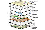
Andrew Davidson Property Development Consultants offers a full suite of geospatial services utilising cutting edge Geographic Information System (GIS) technology. This will help us manage and understand the technical issues associated with your property or development project. GIS utilises overlay technology to allow analysis and understanding of each different component or layer, of your development. Spatial data management GIS offers a format whereby all components of your land division or development project can be viewed in relation to each other. This can include aerial photography, roads/transport, soil data, native and non native vegetation, engineering data, population data, building and masterplan designs, heritage and sensitive use information. Having access to this information offers a rigorous platform for decision making, and provides a value added service allowing a complete overview of the project. Spatial Analysis Spatial analysis is at the core of GIS functionality, allowing an understanding of how disparate themes in a particular area interact with each other. Utilising the 'what is where' capability of GIS, it enables an understanding of proximity analysis. For example:
Data Capture Utilising either desktop analysis from aerial photography or satellite imagery, or from data capture in the field, GIS can assist in creating industry standard spatial data for your project. On-screen digitising from imagery (photo or satellite) can save much field work time by cost effectively isolating and capturing the different elements within your project area. Examples of what could be captured include:
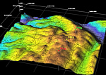
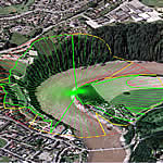
Data capture methods can also extend to on site data capture using mobile GIS software coupled with a GPS. On-the-fly GIS data creation while in the field means that accurately capturing the location and extent of features within your project area, can be undertaken in a fast and cost effective manner. 3D Modeling and Analysis Geospatial technology can be used to create a 3 dimensional model of your project area. Constructing a digital terrain model (DTM) enables advanced analysis such as viewshed and line-of-site analysis and visualisation. Viewshed Analysis This technique allows the developer to understand how the development will impact visually within the existing landscape. Viewshed analysis allows for an understanding of what proportion of the surrounding area, or population, will be able to see the proposed development. Line-of-site Analysis Line-of-site analysis is a geospatial technique which enables the developer to choose a particular point within a proposed development and accurately assess if it can be seen from another point on the landscape. The technique is very good for community consultation issues where visual amenity is of concern to specific surrounding parties. Visualisation 3 dimensional visualisation is advanced geospatial technology, and offers a valuable product for the developer. Using digital terrain modeling, aerial photo overlay and 3 dimensional building/infrastructure models, the developer can accurately visualise how a new housing subdivision or other infrastructure project will look before construction. Before and after images of proposed construction offers a very powerful medium for explaining the form and context of a new development to a range of diverse audiences, such as investors/financiers, community groups and local government planning officials. |
|
| PO Box 654, Glenside, South Australia 5065Click to Contact Us | T 08 8390 0099 | |
| Copyright © 2008 Andrew Davidson Pty Ltd | Privacy Statement (PDF) | A SAmeleon Web Design Project |